It is hard to find a more poetic name for a geographical location. I remember learning about it in high school geography classes and thinking that it would be so wonderful to go visit. Little did I know that it would be possible.
The tip of the peninsula is located about 65 km south of Cape Town, but it took me about 4 hours to drive. The road goes through many touristy towns with really pretty beaches. I took many recommendations from local friends on where to stop and ended up stopping way too many times.
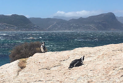
African penguins
The eastern side of the Cape peninsula is washed by the Indian ocean and even though it is not "warm" by usual standards, it is a couple of degrees warmer than the Atlantic (western) side. So I went for a swim in so-called tidal pools:
And then again with the penguins.
CO-EXIST: Simon's town penguin colony and public beach in one panorama shot.
Finally I got to the Table Mountain National Park. The drive up to the tip of the peninsula was really pretty. Like other national parks around the world it is now equipped with plagues outlining the significance of these particular points.
Obligatory picture with the geographical coordinates sign.
Once you get to the end of the road you can hike up to the highest point overlooking the tip of the peninsula.
But the most magnificent view is looking back at the Cape of Good hope. Not surprisingly - this is the view that impressed my grandfather the most as well:
Cape of Good Hope and Dias beach as seen from Cape Point.
December 1959 and December 2016.


.
ReplyDeleteI would love to follow in your grandfather's foot steps too. Sounds like an amazing day. Love those punguins.
ReplyDelete